
 Chris Rowan is a geologist specialising in the dark arts of paleomagnetism, and getting people to pay him to travel to exotic destinations for fieldwork. Having drilled up New Zealand during his PhD, and South Africa in his first post-doc, he now works at the University of Edinburgh.
 Anne Jefferson has a love of all things water-related and blends hydrology, geomorphology, geology, and climate change in her work. She has a Ph.D. from Oregon State University and is now an assistant professor at the University of North Carolina at Charlotte.
![]()
A magnitude 7.0 earthquake struck Haiti this evening, causing extensive damage to the capital, Port-au-Prince, and probably causing many casualties. The map below shows where the main shock occurred (red), as well as the epicentres of the numerous aftershocks (orange) that occurred in the following 5 or 6 hours (and continue even as I write).
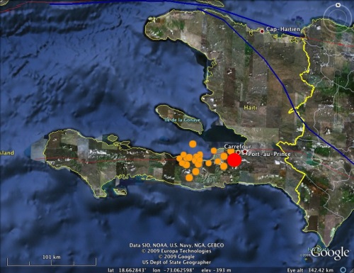
The main shock appears to have initiated less than 25 km southwest of Port-au-Prince; this close proximity meant that the city would have endured the maximum possible shaking intensity from an earthquake of this size, leading to extensive damage. Here's the focal mechanism, courtesy of the USGS:
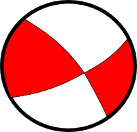
With the help of my recent post on focal mechanisms, it is hopefully obvious that the rupture occurred on a primarily strike-slip fault, with the crust on each side of the fault moving horizontally relative to the other side. To understand why there is strike-slip faulting in this area, we need to step back, and look at a simplied map of the entire Caribbean:
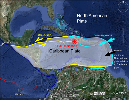
The Caribbean is contained on its own separate little plate; a rather diminutive part of the tectonic jigsaw that is the Earth's crust. It is surrounded on three sides by the much larger North and South American plates, both of which are moving approximately westwards with respect to the Caribbean plate at around 2-3 centimetres a year. On the eastern edge of the plate, the boundary runs perpendicular to the direction of relative plate motion, so there is compression and subduction (and subduction volcanism, exemplified by the likes of Montserrat). However, as the boundary curves around to form the northern boundary of the Caribbean plate, where the Haitian earthquake occurred, it starts to run parallel to the direction of relative plate motion, making strike-slip faulting along E-W trending faults the most likely expression of deformation in this region. This is exactly what the Haitian quake appears to record.
Note also that deformation across the northern plate boundary appears to be distributed - some motion is accommodated on faults that are located a little bit away from the actual plate boundary, further inside the plate interior. The Haitian quake appears to have occurred on one of these faults: based on the position of its epicentre the rupture is extremely close to the Enriquillo Fault, which appears to be a major strike slip fault running across the southern end of Haiti. This is the fault most likely to have ruptured.
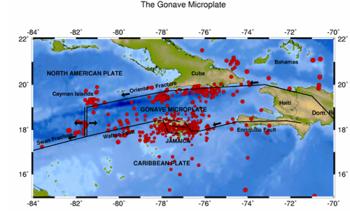 Tectonic map of the Northern Caribbean (Source)
There is nothing particularly unusual about this earthquake given the tectonic context. Unfortunately, however, Haiti is a very poor country - one of the poorest and least developed in the world - so unfortunately, its government was not in a position to really do much to prepare for the inevitable large earthquake, leaving tens of thousands to suffer the consequences.
Geotagging (View all geotagged posts)
Update from Anne: Chris has been featured in a Nature News Briefing: "The Haiti Earthquake in Depth" along with more information about the faults in question and the known seismic risk of the area.


Comments
Excellent overview, Chris. I'll be using it in class in a few hours.
Posted by: Ron Schott | January 13, 2010 2:59 AM
Radio 4 couldn't contact you this morning, so they grabbed someone else from Edinburgh. He said that in the long term there might be aftershocks to the west, e.g. in Jamaica. is this just because most of the fault is to the west, or is there a deeper reason?
Posted by: Bob O'H | January 13, 2010 3:04 AM
Excellent post, Chris. Thanks for writing this.
Posted by: Arikia | January 13, 2010 3:20 AM
Excellent, clear post.
Posted by: Pyers Symon | January 13, 2010 4:06 AM
Thank you Chris this is a very very clear blog site. I can understand a lot more now. Please take care. My thoughts are of the people of Haiti.
Posted by: Deb | January 13, 2010 5:32 AM
Fantastic post, Chris. I think my hydrogeology students will be getting a little dose of tectonics today thanks to your clear explanation.
Posted by: Anne Jefferson | January 13, 2010 6:11 AM
Very nice post!! Enriquillo fault was the first thing I though of as soon as I saw the location of the epicenter. I think that of all the Caribbean islands, Hispaniola is one of the more messed up, tectonically, part of the north is even moving in the opposite direction as the rest of the island.
Posted by: Jorge Velez-Juarbe | January 13, 2010 6:23 AM
Quick, clear work! Thanks, Chris!
Posted by: Callan Bentley | January 13, 2010 7:43 AM
Excellent post. I had also written something and have just added a link to this clear explanation. Thanks.
Posted by: Filipe M. Rosas | January 13, 2010 7:50 AM
Thanks Chris; You have posted a comprehensive overview of the massive earthquake attacked last evening to Haiti. But think we should help them any possible way at least pray for them.
Posted by: DrKeithCurrie | January 13, 2010 9:17 AM
Thanks, Chris - and great explanation.
Posted by: Kim | January 13, 2010 10:20 AM
Thank-you! Quick, clear, and simple.
Posted by: Dixie McCormick | January 13, 2010 10:30 AM
He said that in the long term there might be aftershocks to the west, e.g. in Jamaica. is this just because most of the fault is to the west, or is there a deeper reason?
I don't know for sure, but it may be historical ruptures on this fault were further to the east, so the west is where the most stored elastic strain is waiting to be released.
Posted by: Chris Rowan | January 13, 2010 10:35 AM
I'm gonna get on the bandwagon here ... great post, exactly the information I wanted to know about this event.
Posted by: BrianR | January 13, 2010 10:44 AM
For some reason I was trying to google "tectonic plates Haiti earthquake" before I went "duh! I bet Chris has it" - and lo and behold I was right! You answered everything I wanted to know - great job!
Posted by: Erin | January 13, 2010 11:35 AM
Great post, it's nice to learn the science behind the earthquake. As you pointed out, Haiti is a very poor country with few resources to help recover from this event. If people would like to help there are a variety of organizations they can donate to. I like Mercy Corps https://donate.mercycorps.org/
Posted by: Laurel | January 13, 2010 12:03 PM
Has there been an upthrust of land?
Just noted on the BBC live update page that at 1733:
My italics.http://news.bbc.co.uk/2/hi/americas/8456322.stm
Posted by: chezjake | January 13, 2010 1:02 PM
Structural geology enthusiasts: Looks like a perfect example of plate interaction in transpression.
Posted by: Maitri | January 13, 2010 1:11 PM
It's too bad Haiti has been denuded of trees, unlike the DR. Result: few wooden buildings, too many brick/masonry buildings. I would bet that's the main cause of casualties.
Posted by: Roland | January 13, 2010 3:28 PM
Good post but a comment on "maximum shaking".
If the aftershock and mainshock locations are correct, then the earthquake ruptured from east to west and away from Port-au-Prince. This would mean the maximum possible shaking did NOT occur in the city but likely at the west end of the fault due to directivity effects (which can be significant).
When a large earthquake occurs, the rupture begins at one point and then progresses along the fault, usually at about shear wave velocity (perhaps 2 - 3 km/s). Seismic waves radiated in the direction of the rupture propagation tend to have higher amplitudes than the waves moving in the opposite direction. In the case of the Haiti earthquake, the location of the mainshock denotes the likely nucleation point and the aftershocks will be (typically) clustered along the total rupture. Therefore, *if* the locations on the map are correct, the earthquake started in the east and the fault ruptured along a line to the west.
That said, ground motion also depends on site conditions - if much of the city was built on soft soil rather than bedrock, this would likely increase shaking.
In general, maximum shaking does not always occur near the fault.
http://earthquake.usgs.gov/regional/nca/rupture/directivity/
Posted by: rm | January 13, 2010 3:45 PM
Thank you. Excellent explanation.
Posted by: Alan B | January 13, 2010 5:05 PM
Anyone know how long the quake lasted?
Posted by: steve | January 13, 2010 5:41 PM
I wanted to get your opinion on whether the Earthquake which happened in Northern California (N. American plate) triggered the movement of the Carribean/N. American plates to result in the Haitian quake.
Posted by: Kitty | January 13, 2010 6:50 PM
We haven't heard any reports from Jamaica or Cuba of quake effects. Is this because it is a relatively small quake, or is it simply that slip occurred along a very small portion of the fault?
Posted by: bo | January 13, 2010 7:10 PM
@chezjake: The motion along that plate boundry has been mostly left-lateral strike-slip since the Cretaceous. That is also what is seen along the Montagua fault in Guatemala. However, Cretaceous limestone is also exposed there with a little additional uplift on the north exposing low-grade metamorphics.
http://sp.lyellcollection.org/cgi/content/abstract/328/1/219
Posted by: Dave Crane | January 13, 2010 7:26 PM
We haven't heard any reports from Jamaica or Cuba of
quake effects. Is this because it is a relatively small
quake, or is it simply that slip occurred along a very
small portion of the fault?
The earthquake originated at shallow depth. That reduces areal coverage, but then ground motions are more violent where it is felt.
Posted by: zeke | January 13, 2010 7:33 PM
@kitty: Fault movement in California doesn't affect the faults in the Caribbean. Too far away and too many faults in between that would have been subjected to far greater stress - or absorbed it. This earthquake was predicted, based on local tectonics, in 2008 at a Caribbean Geological Congress by Paul Mann, (et al,) of the University of Texas. "Since the last major event in south-central Dominican Republic was in 1751, that yields ~2 meters of accumulated strain deficit, or a Mw=7.2 earthquake if all is released in a single event today. The two largest cities within 30 km of the fault zone are Port-au-Prince, Haiti, and Kingston, Jamaica, with a combined population of 3.65 million inhabitants."
See http://www.ig.utexas.edu/jsg/18_cgg/Mann3.htm
Posted by: Dave Crane | January 13, 2010 7:36 PM
@zeke: It was felt in Jamaica, but the fault does not seem to have released that far from Haiti. Jamaica is next on the watch list; the quakes are occurring from west to east after several hundred years of stress accumulation. http://sflcn.com/story.php?id=7734
Posted by: Dave Crane | January 13, 2010 7:43 PM
Thanks Zeke, my geology is rusty. Just a note: Haiti is the same size as the county I live in; we have fewer than 40,000 inhabitants. I can't imagine stuffing nearly 10 million people into the same space. That seems like a disaster in itself. I feel badly for Haitians and all other human beings living in those conditions.
Posted by: bo | January 13, 2010 7:56 PM
I totally agree Bo, we are over populated...and some long term plan needs to be formulated...
Posted by: Bulletproof vests | January 13, 2010 8:22 PM
I dont know if we are over populated at this time....but we are getting very close. China, india, philipines, and haiti are all very dense population centers...before long we will not be able to feed them.
Posted by: Rabbit Cages | January 13, 2010 8:26 PM
Population control: two words that send many people into an irrational preference for high casualties in natural disasters, including famine. Nature will continue with mathmatical risk management: quantity versus quality.
Posted by: bo | January 13, 2010 9:22 PM
tank's, it's an example of plate interaction in transpression.
Posted by: Nicolas Gomez | January 13, 2010 10:02 PM